Julian D. Olden, University of Washington
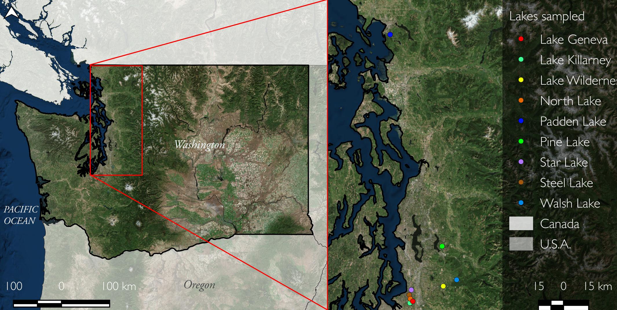
Figure 1 – Nine lakes across a gradient of shoreline development in western Washington
The littoral zone – referring to the nearshore area of lakes where sunlight penetrates to the bottom surface – is a well-recognized hotspot for life. By virtue of its shallow, warm and light-filled waters, the littoral zone supports vibrant plant communities that in turn provide important habitat for fishes, invertebrates, and shorebirds. These same attributes also attract human life to littoral zones to swim, paddle, fish, and engage in a variety of other recreational activities.
To increase access to these amenities and improve lake views, waterbodies throughout North America have been subjected to extensive shoreline development over the past century. The replacement of complex shoreline habitat with manicured landscapes and retaining walls, and the removal of aquatic vegetation and coarse woody debris from littoral zones is now commonplace. This causes substantial reductions in emergent and floating plant diversity, degrades invertebrate biodiversity, decreases fisheries production, and leads to the loss of critical ecosystem functioning such as erosion control.
Best management practices to protect and restore lake ecosystems increasingly depend on robust monitoring approaches that support whole-lake assessments of littoral zone habitat. However, a longstanding challenge is that traditional surveys involving visual assessments from the shoreline, a boat, or by SCUBA divers are time intensive and provide a limited spatial perspective of habitat structure. But as MacGyver once said, “Any problem can be solved with a little ingenuity” (shout out to Generation X). In fact, recent improvements and access to cost-effective camera equipment have resulted in some application of underwater videography to quantify nearshore marine habitats, which led to the question: what about lakes?
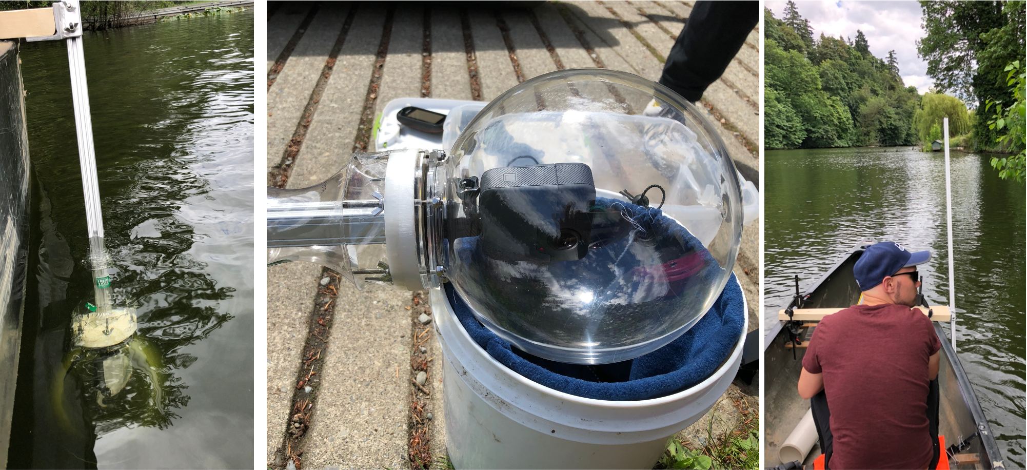
Figure 2 – Videos were captured with a 360° high-definition GoPro video camera mounted inside a waterproof acrylic ball
For nine lakes across a gradient of shoreline development in western Washington (Figure 1), we used underwater videography to map the lake-wide distribution of aquatic plant cover, coarse woody debris and substrate composition. Videos were captured with a 360° high-definition GoPro video camera mounted inside a waterproof acrylic ball. This was attached to a pole and fastened below the water surface to a canoe that navigated around the entire perimeter of the lake at a constant speed (Figure 2). The camera consists of two 18-megapixel lenses capturing video at a 180° wide angle oriented towards the water surface and the lake’s bottom. Next, we stitched the two videos together to produce a 360° video. Time-lapse video, consisting of an image taken every two seconds, was captured as it allowed easy georeferencing. For each image, we estimated percent plant cover (benthic, submerged, emerged plants), substrate type (mud, sand, pebble, cobble, boulder) and coarse woody debris.
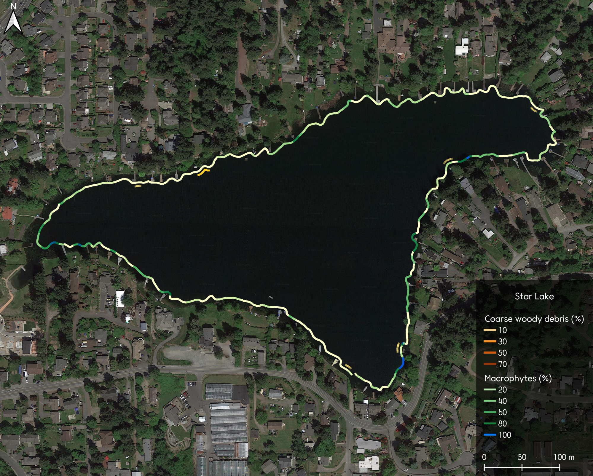
Figure 3 – Lake-wide mapping of littoral habitat of Star Lake in Kent, Washington.
The result was the whole-lake quantification and mapping of lake littoral habitat in a spatially continuous manner, and reveals the patchiness of plant cover and coarse woody debris (for example, at Star Lake in Kent, Washington; Figure 3). Across all lakes, we found that increased shoreline development was negatively correlated with both the cover of aquatic macrophytes and coarse woody debris density, supporting the notion that human occupancy and activities on lake shorelines have resulted in less complex and homogenous habitats. Previous research in our lab has shown that this leads to depressed aquatic invertebrate communities (Twardochleb and Olden 2016), including lower abundance of native signal crayfish (Larson and Olden 2013).
In summary, we feel underwater videography provides a powerful approach for whole-lake assessments of littoral habitat. We are eager to work with lake associations and natural resource agencies to extend this approach to other lakes; for example, to evaluate nearshore restoration actions or monitor the success of projects to remove aquatic nuisance plants.
To learn more, contact olden@uw.edu and visit http://depts.washington.edu/oldenlab/.