by David Cordner, Center for Spatial Information and Research, Department of Geography, Central Washington University.
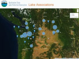
(Fig. 1) WALPA web map – aerial view
Washington State Lake Protection Association (WALPA) helps lake associations and watershed stakeholders coordinate and cooperate to protect lakes. To support this mission, the Center for Spatial Information and Research (CSIR) in Central Washington University’s Geography Department has partnered with WALPA to develop a Web-based interactive map of active lake associations in Washington and Idaho. The map shows the groups’ locations and displays their mission statements, contact information, and issues of concern.
The WALPA web map promotes lake protection in several ways. It helps lake residents find existing associations and connect with neighboring associations to share resources and knowledge in dealing with common problems. The map also allows WALPA to connect more easily with local organizations to tell them about new educational resources, conferences, and events, or mobilize legislative support for lake issues quickly.
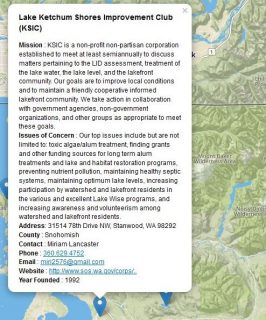
(Fig. 2) Each group’s information is displayed when the marker is clicked
Association locations are displayed as markers on the map; a popup window shows each group’s information when the marker is clicked using the mouse cursor (Fig. 2). When the map is zoomed out, overlapping markers are clustered (Fig. 1). A proportional circle shows how many associations are in each cluster. To view areas of interest, the user can pan and zoom, and toggle between a base map showing streets or aerial photographs. Additional data layers related to current events or initiatives can easily be added to provide map users more information.
We will continue to add features as we develop the map further. For example, lake associations will soon be able to add their locations and information directly to the map. WALPA will also be able to prompt users to complete online surveys and download data directly to their membership database.
The map application is being developed using free and open source software. Check it out at http://www.gis.cwu.edu/geog/walpa/. With your help promoting and using it, the WALPA lake association map will become a valuable resource for information sharing and education among Washington and Idaho lake advocates.