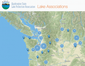
Lake Associations of Washington map
WALPA is excited to announce that our new interactive lake association web mapping tool has gone live! We invite your lake group to add your information. WALPA developed this new tool to improve communication and coordination among lake groups across the state of Washington and including our neighbors in Idaho.
We need your help to make this tool the best it can be! Simply complete a short survey to add your lake association or update your information. All types of lake groups, formal or informal, can submit their information.
Please help improve the tool by making sure your information is current — some of the information is more than ten years old, as it was based on WALPA’s old printed list.
The map will help your group:
- Connect with other lake groups working on similar problems
- Involve residents new to your area
- Learn about lake-related funding opportunities
- Have a voice at the state level on lake-related issues
With your help promoting and using it, the WALPA lake association map will become a valuable resource for information sharing and education among Washington and Idaho lake advocates.
A huge thank you goes out to the Center for Spatial Information and Research (CSIR) in Central Washington University’s Geography Department. They donated their valuable time and resources to help develop this fantastic interactive map.
If you have any questions about the map, please contact info@walpa.org.