by Madison Schumacher, Environmental Science Master’s Candidate, University of Idaho
It’s 5 a.m., and the sun’s first rays are emerging over the mountain peaks, casting a gentle warmth upon us on the shores of Lake Coeur d’Alene, the gem lake of northern Idaho.
“Driver, do you copy?” I inquire via the two-way radio, batting away pesky mosquitoes in the soft morning glow at Blackwell Island.
“I hear you,” crackles the radio. “We’re positioned for the 400-foot pass, and we’re ready whenever you are!” Bob responds. He’s a dedicated local community scientist volunteer contributing to our research, and our trusted boat driver for the day. In the community science model, the Bay Watchers — which consists of a group of public volunteers on Lake Coeur d’Alene — collaborate with scientists from state agencies and local educational institutions to undertake scientific research on the lake.
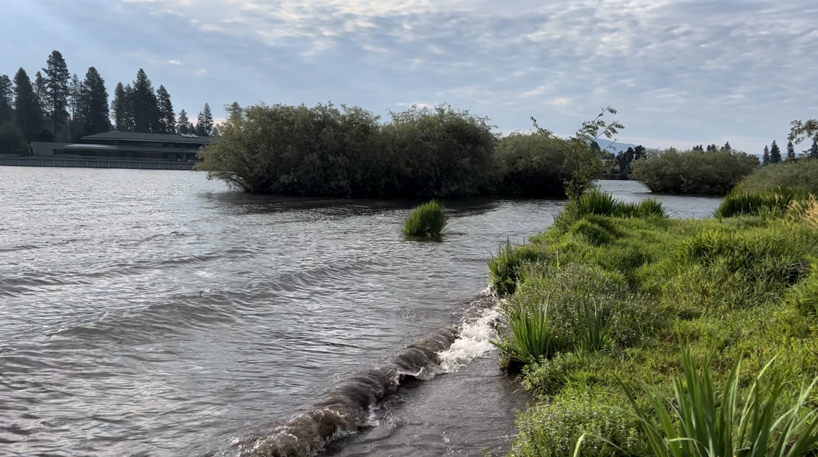
Example of a wake disturbance in the nearshore of Blackwell Island across from the Harbor Center in Coeur d’Alene, ID.
Today marks our first field sampling day of the 2023 season, during which I aim to quantify the role of natural wave and boat wake disturbances (caused from natural wind versus boating activities) in the resuspension of sediment, nutrients, and metals in the nearshore of Lake Coeur d’Alene. The project brings a team of community scientists from the Coeur d’Alene Bay Watchers into a collaborative scientific exploration with undergraduate student researchers and scientists from the University of Idaho, the Idaho Department of Environmental Quality, and me, a graduate student pursuing a Master’s Degree in Environmental Sciences at the University of Idaho. After much planning, I’m excited to see what today will bring.
On shore we’re set up to sample the impending waves Bob and the other volunteers aboard the pontoon boat are about to create.
“All right, the team is standing by for your wake disturbance. Accelerate to the required speed and complete the first pass,” I say into the radio.
“On our way,” Bob acknowledges.
“It’s go time, everyone!” I say to the shore crew. Garret is set to collect measurements of wave height; Brooke will record turbidity data from the underwater Data Sonde set at a water depth of 0.5 meters; Cody has already set the level loggers and tilt meter and will time the sample collections, while I’ve set the video recording and will manage the water sampling. Everyone handling water samples is wearing gloves to avoid contaminating samples, or potential contamination from the water itself – one of the unknowns at this point. Time is a pressing constraint this morning, as we need to complete multiple boat passes at three different bays before the day’s winds pick up or other passing boats disrupt our sampling regime.
We observe the rhythmic advance of waves from Bob’s pontoon boat, originating from a pass 400’ distant from our sampling station, eventually culminating in a frothy crash along the shoreline. The water right next to shore immediately became distinctly murky.
“Wow – it looks like chocolate milk!” Garret exclaims, his voice intermingling with periodic measurements of wave heights.
“How did that look?” Bob inquires through the radio.
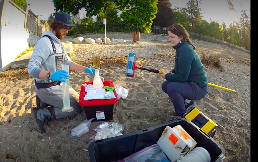
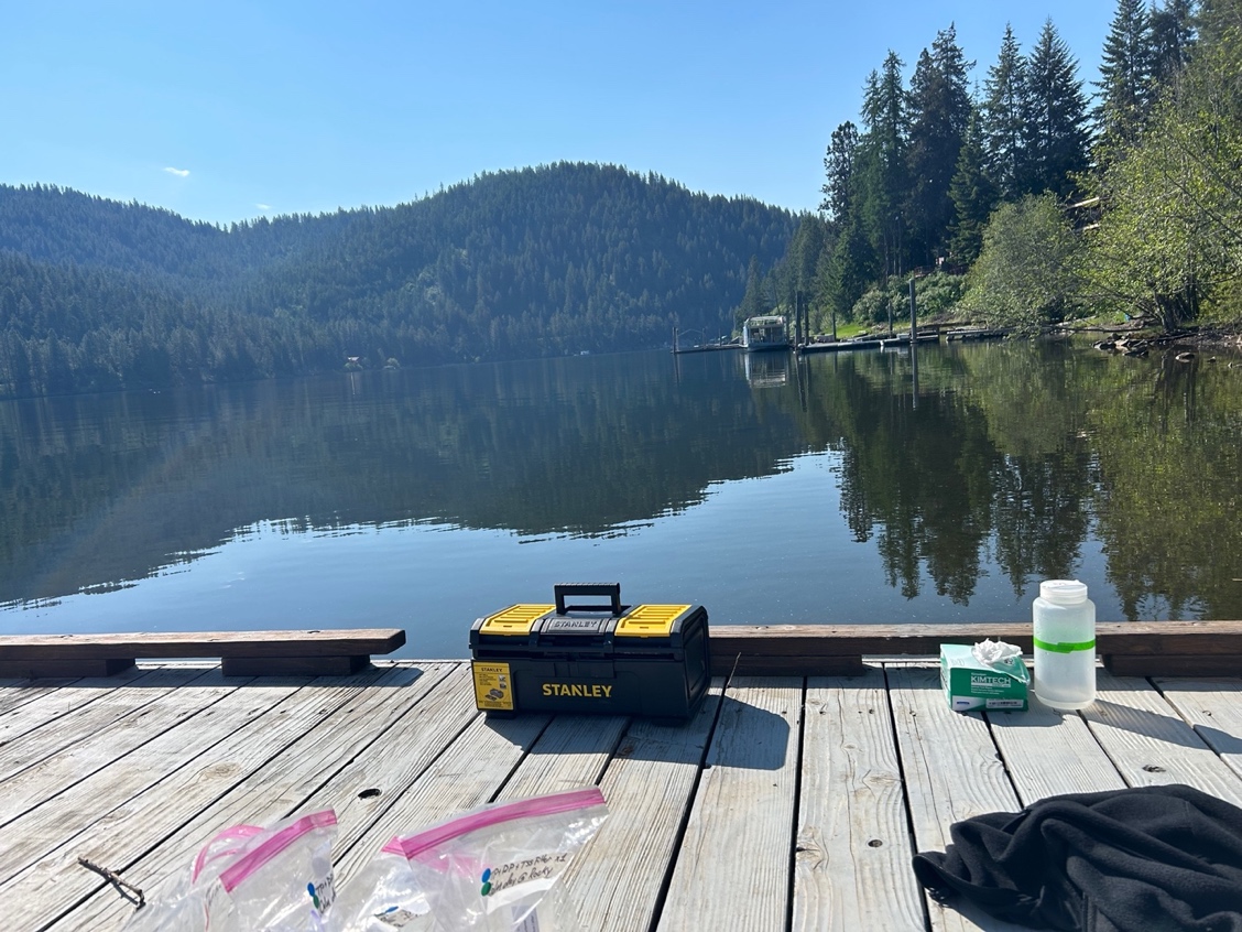
Cody Wilkin & Maddy Schumacher preparing to filter for Total Suspended Solids present in the water at Sanders Beach in Coeur d’Alene, ID.
“Perfect. We’ll need about 15 minutes to process the water samples,” I reply as I meticulously pre-rinse the sample bottles. The water samples collected this morning will be analyzed later in the lab for total and dissolved metals, phosphorus (an essential nutrient in lakes), total suspended solids, and turbidity (or cloudiness in the water column). In preparation for the dissolved metals and phosphorus analyses, we immediately filtered the water samples through a 0.45 micrometer membrane filter and put them on ice to prevent any changes in chemistry.
“Understood. We’ll head to the 200-foot marker for the next pass,” Bob confirms. After that pass, it was down to 100’ from shore, and then on to two more bays with different sediment types, sandy and rocky, along the shoreline. Bob’s dedication extended beyond his volunteering for the water chemistry aspect of the study; both he and his wife Barb, alongside ten other community members from the Bay Watchers program, actively participated in our research by observing and documenting boat activities for multiple days throughout the recreational season on Lake Coeur d’Alene. Their commitment to the project was invaluable. I will use these observational data in conjunction with daily images from satellite passes to create an index of boat activity during the summer. This will allow me to calculate the season-long total boat wake contributions to nearshore disturbances.
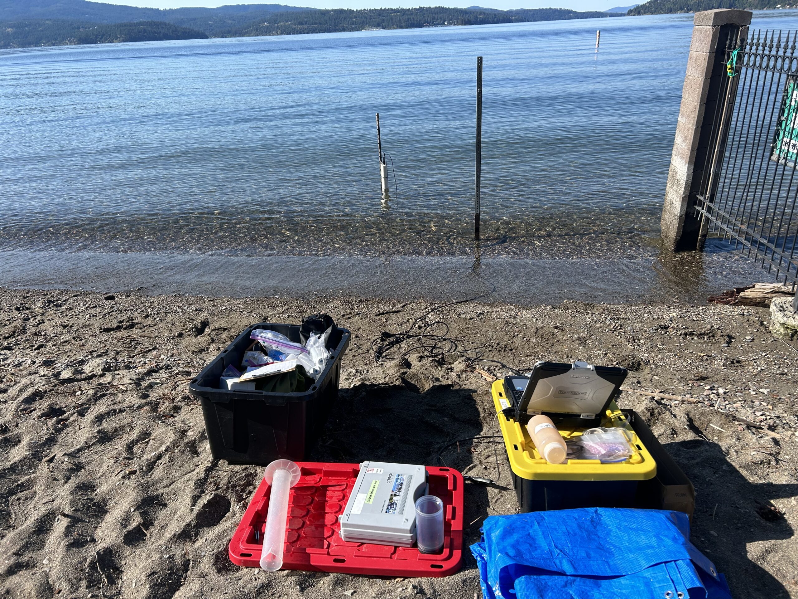
The sampling equipment set up at Sanders Beach in Coeur d’Alene, ID.
Our research site, the picturesque Coeur d’Alene Lake in northern Idaho, is a breathtaking waterbody that is immensely popular, as evidenced by numerous marinas, luxurious waterfront hotels, and an abundance of private houses along its shores. It is an ideal place to embark with family and friends on boating adventures, fishing excursions, swimming outings, and enjoying scenic vistas. However, below the water surface of this seeming paradise lies a complex concern. The lake sediments contain both nutrients from human development throughout the watershed and legacy deposits of mining waste from the Silver Valley upstream of the lake. As such, our research team is interested in quantifying the role of nearshore disturbances from wind waves and boat wakes in the potential resuspension of these constituents into the water column where they could be a cause for concern.
The resuspension of nutrients and metals could pose multiple threats. Firstly, the survival of fish eggs and fry is known to be adversely affected by elevated metal concentrations and turbid waters. An influx of nutrients, such as high phosphorus concentrations, can contribute to harmful algae blooms that have the potential to result in ‘No Contact’ advisories for humans. Such an influx may also negatively affect fish populations when the algae eventually dies and decomposes, depleting the water of dissolved oxygen. Metals that may resuspend from the sediments can be absorbed and accumulated in the tissues of aquatic organisms, and if ingested or absorbed by human recreators, can result in severe health issues such as cancer, organ damage, and other serious ailments. These risks are particularly heightened when exposure occurs over prolonged periods or involves high concentrations of metals. Furthermore, elevated turbidity diminishes the value of source waters, not only due to reduced visual appeal but also because of increased costs associated with water filtration to meet quality guidelines. With the increasing human population and subsequent pressures on our lakes, we need to understand what is happening in the nearshore, the place where most of us are likely to get into the water. That, precisely, is the goal of my MS thesis.
The beautiful view while sampling at Powderhorn Bay.
In early April, when water levels were low enough to see the underlying sediments, we boated around the lake and selected study sites representative of the major types of sediments present in the lake. This summer, my team and I monitored each study site on multiple calm and windy days without boats, as well as on calm days with wakes generated by three types of boats (pontoon, jet ski, and wake boat) operating at different distances from shore. We measured wave height and turbidity, and collected water samples for the analysis of total and dissolved nutrient and metal concentrations.
I also engaged community scientists from the Bay Watchers group to record the nuances of boater activity (the social science component of my Environmental Science thesis). During the summer of 2023, ten volunteers dedicated approximately 78 hours to observing boaters on the lake, from the beginning of June through Labor Day. They observed how far boaters operated from shore, what kinds of activities occurred, how many people partook, how often and how long the activities lasted, what types of boats people used, etc. I’m currently in the process of analyzing the data they’ve gathered. The aim is to weave their observations and stories into a narrative that sheds light on how the lake is being used, the concerns of the local community, and how these insights connect to the quantitative research. I also plan to use daily satellite imagery to count all boats on the lake at a specific time and cross-reference to observations from the Bay Watchers. This way, I will have not only a snapshot of activity at a busy time, but a way to generalize when detailed observations were not made. Involving community scientists in this social survey greatly enhanced the feasibility of my research. By collaborating with more individuals, I was able to obtain many observations at multiple sites, engage local residents with their environment, and learn from their experience.
It will be important to complete the circle by re-connecting with the volunteers and sharing my results. I’m planning to present to and offer discussion groups with the dedicated volunteers this spring. These gatherings will serve as an opportunity to reflect on the study’s progress, further gain insights into the volunteers’ perspectives on the lake’s most significant issues, as well as the lessons they’ve acquired through participation. As a facilitator, I’m committed to fostering an environment where everyone feels comfortable sharing their perspectives, ideas, and constructive criticisms. As we move forward into the spring, my plan includes ample time in the laboratory, processing the phosphorus samples and conducting a comprehensive analysis of all the gathered data. There’s much to analyze, and we anticipate that the results will become available in the spring, shedding further light on the dynamics of the Lake Coeur d’Alene ecosystem.
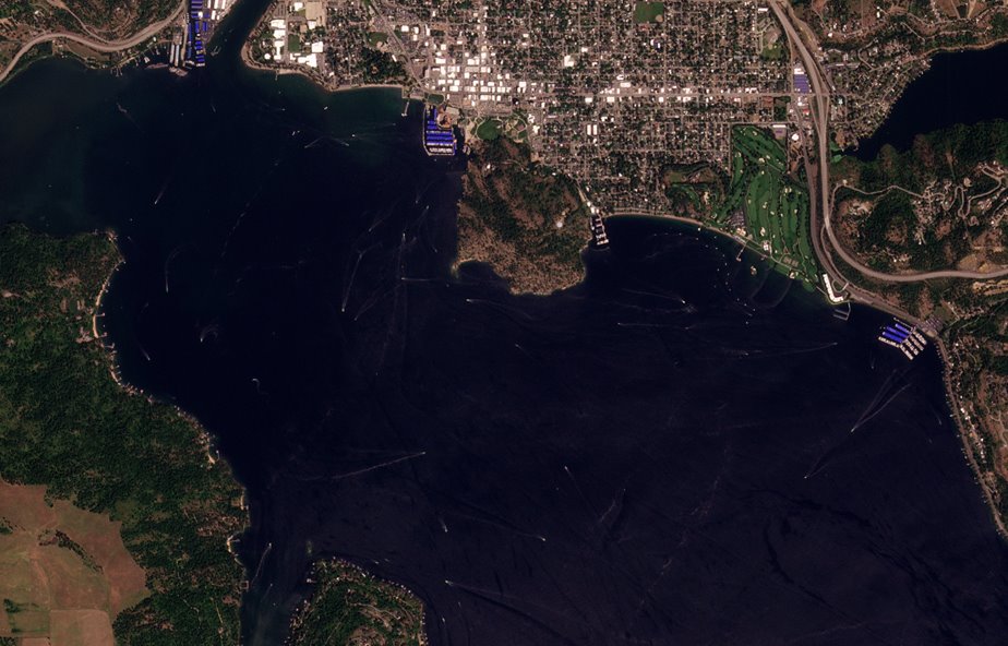
An example of a satellite image from Planet Scope of Lake Coeur d’Alene on July 4th, 2023. ( “Image © 2023 Planet Labs PBC”, Planet Application Program Interface: In Space for Life on Earth, 2018-2023. Accessed August 19, 2023. [https://api.planet.com]).
Acknowledgements
I would like to express my heartfelt gratitude to everyone who supported me throughout this summer, whether it was by dedicating their time to observations, contributing boat hours, providing transportation, opening their homes and properties, sharing words of advice, or by offering valuable training. Your contributions have been instrumental in advancing our research. This research wouldn’t have been possible without the dedication of volunteers from the Bay Watchers program, especially Wanda Quinn and Sharon Bosley. Thank you to the Idaho Department of Environmental Quality for providing training and allowing us to borrow instruments. Thank you Kootenai County, Washington State Lake Protection Association, IDEQ, Aquatechnex, the University of Idaho Graduate & Professional Student Association, and the Environmental Science Department for funding this research.